
To study how an extension to the navigation system might be constructed in rugged terrain one pentacle (shown in turquoise) was selected.
This selection was not totally at random, as an alignment from this pentacle provides the intersection with the Brenac pentacle.
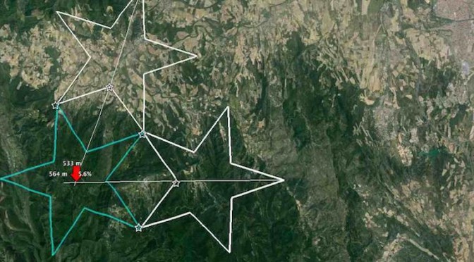
The Location
 The pentacle is also situated between two alternative routes which the Visigoths might have used travelling south from Carcassonne.
Thus this area is typical of where the treasure might have been hidden.
 A little practical work soon showed that the use the pentacles as a navigation system was a very valid alternative to conventional triangulation.
A relatively simple methodology can be devised.
The two white pentacles are considered as “existing” pentacles. Both pentacles are in the departement of Aude, the one on the left could be associated with the village of Villefloure and the one on the left with Sainte Hilaire.
The Terrain
The turquoise pentacle is a new pentacle which it is desired to construct as an extension of the navigation system. The first stage would be to extend centre lines from the two existing pentacles to the point at which they intersected.
 This 3D view gives a good idea of the terrain and gives a feel for the difficulty of carrying out surveying work in this location. Both centre lines cross changes in level.
Elevation Profiles
 Initially I could not image how there could be any accuracy in constructing these extensions.
The elevation profiles provided by google earth are also very helpful in getting a feel for what is entailed.
<
Equipment
 It can be seen from both this and the previous diagram that the cetre of the new pentacle is slightly over the top of the hilltop from the points from which the extrapolation is being made. There is an excellent website called Elementary Surveying Equipment which sets out how the extrapolation might be done.
In principle it requires lots of straight poles, fitted with flags, which can be reiteratively aligned for as far as is required. Measurements are then made with lightweight chain of only 20 metres in length with pegs being driven in to be inline with the poles.
 It is clear from the web site that it is possible to carry out complex layouts. The North South lines (actually three degrees east of north) must be extended across the area to be occupied by the new pentacle. The North- South lines shown here running through this area run from Lille to Barcelona. As indicated under Navigation Solution many sets of these lines can be drawn along the main alignments of the pentacles. However in this example there is no need to consider the other orientations.