I believed that the Visigoths, under attack from the Franks, retreated first to Carcassonne and then to to Rhedae. From the theories about Possin’s tomb I knew that the Paris Meridien ran through this area. From somewhere I had learned that the Paris Meridien was known as the Devil’s line.Now the number 666 had jumped out of the analysis of the Brenac tablets. Could these two pieces of information have any relevance?
The Paris Meridien
 It did not take long to discover that the Paris Meridien does indeed pass through the eastern edge of the plain on which Rhedae is situated.
Arago
 This same line of longitude is marked through the centre of Paris by the Arago medallions, embedded in the pavements. It is soon to be marked for it’s complete length through France by a line of trees. ( A Bicentennial project which has made uncertain progress).
Dominique Stezepfandts, a French conspiracy theorist, assigns some kind of occult significance to the Paris Meridien; “an occult geographical line”; “the heart of the Devil.”
Henry Lincoln, argues that various ancient structures are aligned according to the Paris Meridian. They even include medieval churches, built long before the meridian was established according to conventional history.
David Wood, in his book Genisis,confirms that the meridian passes about 350 meters (yards) west of the site of the so-called “Poussin tomb”.
Observatory
 Much has been written about the Paris Meridien in the last ten years and most of it has been inaccurate. It does pass through the Paris Observatory, which is not surprising as the observatory was built to lie on the line.
 Even this is not without controversy. It can be clearly seen that this line is on 2° 20’11.39″E. There are many who have walked the Arago line through Paris and taken GPS readings. There is a remarkable consistency that the line is actually on 2° 20’11.41″E.
Discrepancy
 However much published literature stipulates that the correct line is on 2° 20’14.03″E. Only a few seconds but enough to make the line miss the observatory.
 It is almost certain that the founders of the observatory got it right (in 1664) so there must be some sort of a problem with the datum. This is not surprising as although we are continually told that the Grenwich Meridien is the Prime Meridien in fact this is no longer true. The international standard is now the International Earth Rotation and Reference Systems Service (IERS), which is 5.33″ east of the Grenwich Meridian. Sadly even this does not explain the discrepancy in the position of the Paris Meridian.
 A diiferent view of the line as it passes through the observatory shows the gardens and palace of Luxembourge, which clearly were meant to be on the line but are in fact slightly askew. On the ground it is only the location of the Arago medallions which reveals this mistake.
 In turn, a closer view of the palace clearly shows the magnitude of the mistake.
The grey church in the centre of this view slightly to the left (west) of the line is St Sernin. This was the church which Dan Browne in the “Da Vinci Code” claimed lay on the line . Clearly it does not.
The Louvre
 The line does pass through the Louvre. However it does not pass through the inverted pyramid (Pyramid Inverseé). This again was a Dan Browne invention, supposedly the final resting place of Mary Magdelene. My daughter Kirsten’s presence in the picture helps gives some idea of the scale.
 The line does not pass through the entrance pyramid either, (which is supposed to have originally been designed to have 666 panes of glass). Incidentally the inverted pyramid is located under the traffic island to the left (west) of the entrance pyramid.
Sacre Coeur
 The line comes close to many well known places of interest but does not pass through them. These include the church of the Sacre Coeur on Monmarte (Hill of Martyrs).
 La Cité, the medieval city of Carcassonne.
 And the newly completed church of the Sagrada Familia in Barcelona.
The Devil’s Line
 It’s reputation as “The Devils Line’ is enhanced by the fact that the distance from Paris to Jerusalem (Observatoire to Knessus) is 2073 miles.
The Roman Empire distance was measured in feet, miles and leagues. Initially the longer distances were measured by “paces” which comprised two strides of a roman centurian. Obviously these distances were variable. The foot was defined in an attempt to standardise these measurements.
The Drusus Foot
The “Drusus” foot was one of many standards used to define a foot a rod was produced of the specified length and this could be copied and used throughout the Roman empire. This variant of the foot approximated to 334mm. A roman mile was 5000 roman feet so a mile based on the Drusus foot was 1,670,000mm. One version of a roman league was three roman miles so a Drusus league was 5,010,000mm or 5.01 KM.
This attempt at Standardisation failed even within the empire a slightly shorter foot was advocated and by the time of the fall of the western empire there were as many feet as there were identifiable localities.
The definition of both the foot and the mile based on the foot then were varied. again there were many variations. The English foot ended up as 304.8 mm and the english mile was defined as 5280 of these feet.
Therefore an English mile ended up as 1,609,343 mm. In 1959 this was further refined to 1,609,344mm and this is what is used in Google Earth
Therefore converting 2073 miles to Drusus leagues 2073*1,609,344/5,010,000 =666! The devil’s number! So the 666 identified at Brenac might be not so much of a warning as a location, somewhere alone the Paris Meridian.
See the separate page “measurements” for a more complete picture of the variations of foot, mile and league. This is only a small sample of the different standards in use!
Another Co-incidence
 Amazingly the distance from where the line crosses the Spanish coast near Barcelona to where it crosses the french cost at Dunquerque is 666 miles. Just a co-incidence?
However this latter measurement is in English statute miles and as from my investigation of distances the english mile is different in size to any other unit of measurement and therefore could not have had any meaning when the Meridian was chosen. Nevertheless this is intriguing and it drew my attention to the fact that although the line is supposed to run from Dunkirque to Barcelona, it misses the “old” city of Barcelona by quite a long way.
 I drew a line from the centre of “old Dunkirk’ picking up the bell tower.
 I set the end of this line to “old Barcelona”,which was easy to locate as it is the site of the Olympic facilities on montjuich.
 Low and behold from where the line crosses the coast at both ends the total distance is 671 miles and if converted to “Drusus’ Miles this is that number again – 666!
Impossible!
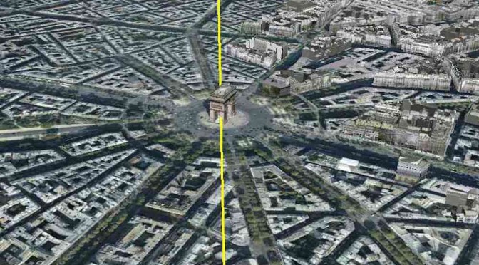
 This is not the end of this particular story however. I was interested to see how far away the line through Paris was from the observatories. Not far as it turns out, but just look at this alignment. Directly through both the Eiffel Tower and the Arc de Triumphe! What!
 Here is confirmation the line passes directly through the arc as well as through the tower. My first instinct was that this was ridiculous, the construction of the Arc de Triomphe commenced in 1806 and was only completed in 1836 The Eiffel Tower was built in a much shorter period in 1888/1889. What can these modern structures have to do with alignments which are supposed to be relevant to a time over a thousand years earlier? What we do not know, of course, is what was previously on the same sites before the construction of the two famous modern edifices, or indeed what was the significance of the sites themselves.
 I realised that there must some connection as the same line, which I constructed by accident, also passes through the Quillan point of the Mazerou pentacle. As far as I can make out this one line running from Dunkerque to Barcelona which has a length of 666 Drusus miles passes through only three significant points- the Arc de Triomphe, the Eiffel tower and the Quillan point of the Mazerou pentacle.
Well known
More research revealed that to French academics this is in fact a very well known and well documented line. When the revolutionary government in 1800 decided to abandon the old “Royal” measurement they decided that the new base unit, the metre, should be one ten millionth of the distance from the earth’s equator to the north pole at sea level. They then chose the longest land path available to them which could me measured, and this line was the line they chose! Everyone would have been amused when it turned out to be 666 Drusus miles., the metre.
In fact for the measurement they chose a slightly different line the yellow line is from river mouth at Dunkerque to river mouth at Barcelona. The decided they wanted a basis for repeatable measurements from the fort on top of Montjuiich in Barcelona to the Belltower in Dunkerque. This measurement line still passes through the Brenac pentacle but not through the Eiffel tower and the Arc de Triumph.
Cassini
Or of course it is possible this line was chosen because it had some other significance perhaps because it’s length was already known!there is another curiosity the mapping of France by the cassini family who used triangulation took from 1625 to 1845 and occupied four generations of the cassini family. superimposed on this was the execs to determine the length of a metre by Delambre and Mechain which took only seven years from 1792 to 1799. Perhaps they performed this supplementary task relatively quickly because they were using other information. There is no clear connection between this alignment and the location of the treasure. However what it has done is to reinforce in my belief in the significance of the Mazerou/Brenac pentacle.
The Brenac Pentacle
 With attention focussed on this pentacle it seemed sensible to examine it more carefully. The length of the side of the pentacle stretching from Brenac to Campagne is, as can be seen from this diagram, 3.17 International Miles
Reference to the Measurements page shows that this is 5.16 Kilometres or exactly 1 Bordeaux League. I place little significance in this except it probably means that the constructors of the brenac pentacle – and it was constructed, only one point was not man made, were workng in a totally different time period from when the decisions were made about the positioning of the Paris Meridien. The use of the Bordeaux foot, mile and league came much later than the “Drusus” equivalents.
The Lincoln Pentacle
 These bizarre alignments and measurements are widespread. Pursuing the use of the Bordeaux mile and the concept that that the pentacles were created at a different point in time from the Dunkerque Barcelona lines I searched Lincoln triangle for a dimension which was an integer. I discovered the the radius of the circle circumscribing the pentacle is 3.44 km.
Again by reference to the distances page it can be seen that this is 2 Bordeaux miles or 0.666 bordeaux leagues.
That is not, all although the Kilometer was not defined until long after the defining structures were placed on the points of these pentacles.
The angle measured clockwise from the south is 344 degrees. of course normally azimuth angles are measured clockwise from the north, but even so!
So we have visigoths with all the treasure then they bring it back to France they then are all killed out so at what point dose Saunier come into play and where exactly did the visigoths base themselves.
Good question, Josh. But in fact they were not all killed. They retreated first to Carcassonne and then to Rhedae, which is where the little village of Rennes le Chateau stands today.
I will spell it out in detail on this page. Were did Saunier come into it? I will deal with that on a separate page.
Love Grandad.
so the Visigoths did not die out at all they lived for a while in the new area around carcason. this would obviously lead to them hiding the treasure. The problem is we dont know where in that area. Did they stay in that area or did they migrate again? and if so did they bring the treasure or take what they could and run or even left it for a later pick up. If there was supposed to be a later pick up then we wont have any prof because they would have kept it low key.
(exam week is over and so can reply more as there is less revision.)
Yes josh, you have got it right. I am currently spelling it out under “rennes le chateau”.
There is another factor however. There is also an opinion that the treasure could be from several other sources which I will identify soon under “Which Treasure”
I will perhaps leave that to a little later and on the next page deal with the Abbe Saunier